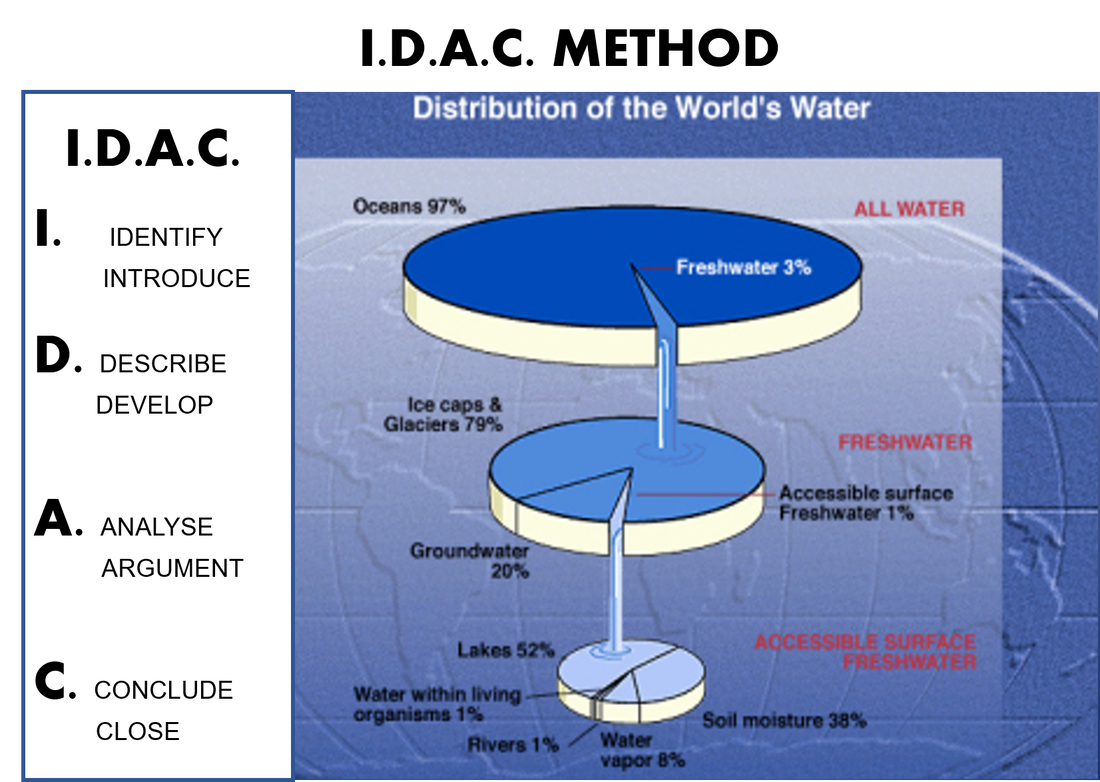
GEOGRAPHY AND HISTORY
1ESO SOCIAL STUDIES
  • HOME
  • IES ÁNGEL CORELLA
  • DOCUMENTS AND MATERIALS
  • CV HOMEWORK
  • NEWS
    • Supporting materials
    • Handouts
    • NEWS PRESENTATIONS >
      • 2016-17
      • 2018-2019
  • MAPS
  • Developing skills in History
    • TIMELINES
    • CLIMOGRAPHS
    • Mind Maps
    • Presentations
  • GEOGRAPHY
    • UNIT 1: PLANET EARTH >
      • Power point revision
      • Homework
      • Mind map unit 1
    • UNIT 2: THE EARTH´S PHYSICAL CHARACTERISTICS >
      • Power point revision
      • Mind map Relief and Hydrosphere
      • I.D.A.C and some homework
      • Projects and presentations >
        • 2013-14
    • UNIT 3: THE CONTINENTS
    • UNIT 4: THE CLIMATE AND BIOCLIMATIC ZONES >
      • Power point revision
      • Homework
      • Projects and presentations >
        • 2012- 2013
    • UNIT 5: THE EARHT´S MAJOR BIOCLIMATIC ZONES >
      • Project
      • Homework
    • UNIT 6: EUROPE/SPAIN
    • UNIT 7: LANDSCAPES >
      • Homework
      • Projects and presentations >
        • 2013- 2014
  • HISTORY
    • UNIT 8: PREHISTORY >
      • Power point revision
      • Homework >
        • Prehistory timeline
        • Human Evolution chart
        • Paleolithic and Neolithic
        • Art and tools foldable
      • Projects and presentations >
        • 2013-14
        • 2016-17
    • UNIT 9: MESOPOTAMIA >
      • POWER POINT REVISION
      • Homework
      • Projects and presentations >
        • 2012-13
        • 2013-14
    • UNIT 10: EGYPT >
      • POWER POINT REVISION
      • Homework
    • UNIT 11: ANCIENT GREECE >
      • Power point review 2017
      • Homework >
        • Homework 2013-14
      • Projects and presentations >
        • 2012-13
        • 2013-14
    • UNIT 12: ANCIENT ROME >
      • Power point revision 2017
      • Homework
      • Projects and presentations >
        • 2012-13
        • 2013-14
    • UNIT 13: ANCIENT IBERIAN PEN. >
      • HOMEWORK
      • Homework
      • Projects and presentations
  • SUPPLEMENTAL MATERIALS
  • TRIP TO DUBLIN
    • General information
    • Blog 2013
    • BLOG 2014
    • Blog 2015
  • ANNOUNCEMENTS
    • Upcoming exams
    • General information
  • Mannequin Challenge
  • Blog
  • EVENTS AND OTHERS...
    • Carranque excursión 2019
    • CARRANQUE´S EXCURSION 2018
    • CARNAVAL 2017
  • Coronatareas
  • Link Page

I.D.A.C METHOD

idac_method_water_diagram.docx
File Size: 2283 kb
File Type: docx
Download File

Picture
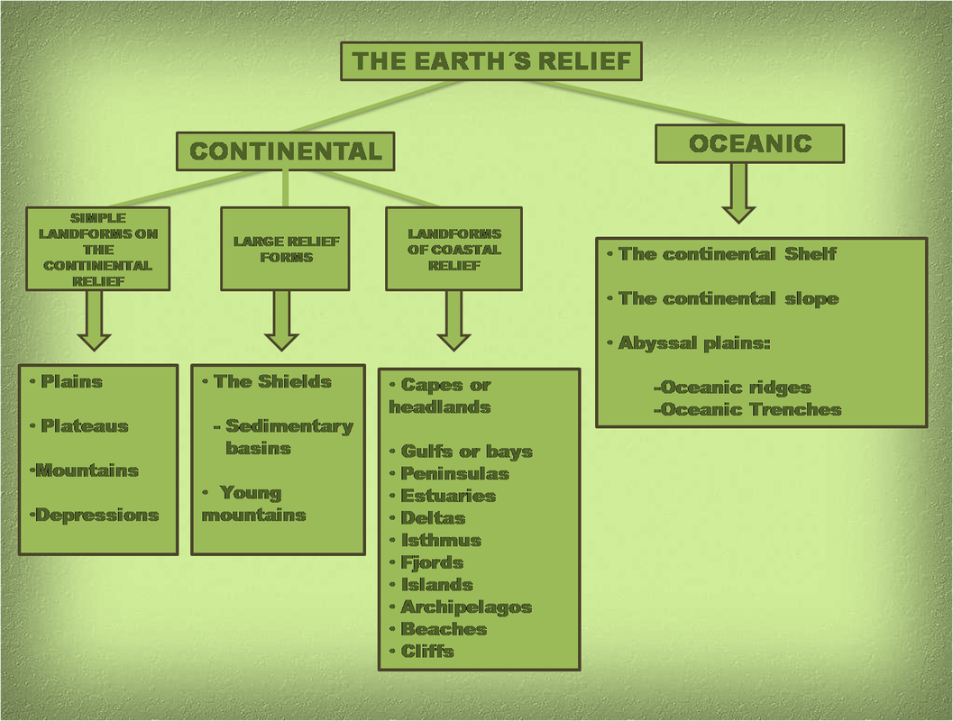
Here you have the slide about continental relief. Complet your outline in your notebook and try to add some pictures or drawings that explain them.
Imagen
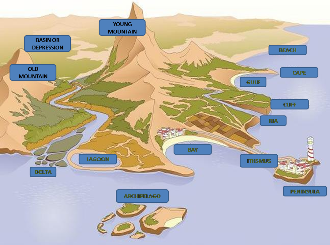
And this is the key to correct the wordsheet I have given you. Remember that you have to glue it to your notebook.
Imagen
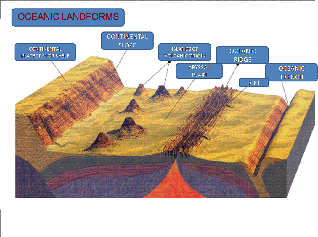
This is the diagram corresponding to the Oceanic Landforms. Make sure you have all the features in the yours.
Imagen
Powered by Create your own unique website with customizable templates.